FLOODING
Flooding is due to a number of different processes. These processes include 1 - Meteorological Processes, 2 - River Valley Process and 3 - Water cycle processes.
Water Cycle Processes
Stages in Rain Formation
1 - Warm moist air rises,
2 - Air Cools,
3 - Water Vapor in the Air Cools,
4 - Cloud Forms as Water Droplets gather together,
5 - Raindrops form,
6 - Rain falls.
1 - Warm moist air rises,
2 - Air Cools,
3 - Water Vapor in the Air Cools,
4 - Cloud Forms as Water Droplets gather together,
5 - Raindrops form,
6 - Rain falls.
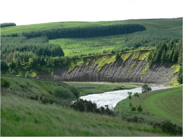
River Valley Processes
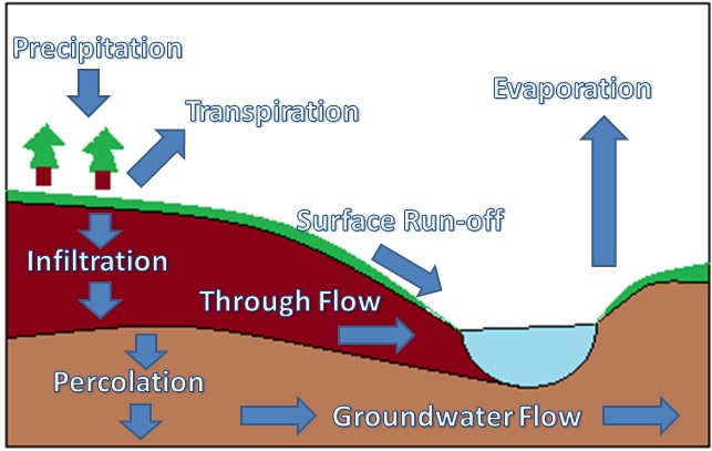
The picture shows the number of processes that occur in a River Valley System. As rain falls (Precipitation) it is either evaporated, or transpired (evaporated from plants). The precipitation also gets absorbed into the groundwater system by a method known as infiltration and percolation. The water is then transferred to rivers or ground water flow by means of through flow or surface run off.
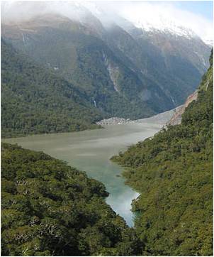
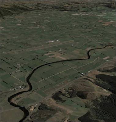
River Valley System
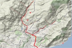
The photo shows the Leith River Valley System. This area shown is the catchment area. This map shows that the Leith River has many tributary streams. In heavy rain the tributary streams flow into the Leith River causing the river to increase in flow rapidly. Often the Leith River will flood. A number of methods have been added to the river to speed up the flow of water. It is interesting that in some cases concrete roads etc. actually cause the river to flood easier as more water travels into the river faster as it would normally be absorbed into the ground water system.
Methods used in a river to speed up the flow of water.
Meteorological Processes
The three types of rainfall that are included here are - Orographic rainfall, frontal rainfall, & convectional rainfall.
Orographic Rainfall
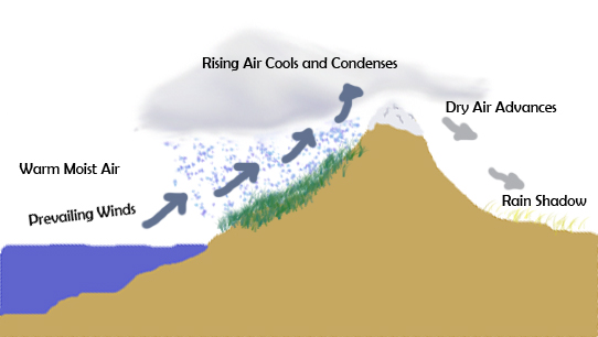
Orographic rainfall occurs when warm westerly winds hit the Southern Alps of New Zealand. The warm moist air is forced to rise over the Southern Alps. As the air rises it cools and water droplets form creating rain. This is why the Canterbury region experiences warm westerly winds while at the same time it is pouring down on the West Coast. The warm winds that Canterbury experiences is know as
Convectional rainfall
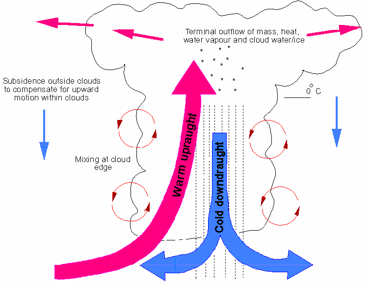
Convectional rainfall occurs when an area experiences a hot dry day. The ground is heated by the sun such as in the tropics, the warm air is then forced to rise cooling as it gains height. As the warm air rises the vapor in the air cools and creates water droplets which form as rain.
Frontal rainfall
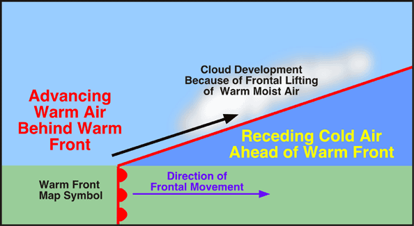
Warm Front - As a warm front approaches a cold mass of air the warm air is forced over top of the cooler air. As the warmer air rises over the cool air it will also cool creating moisture and water droplets. A warm front will show on a weather map as half circles on a line and is generally red.
.
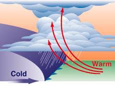
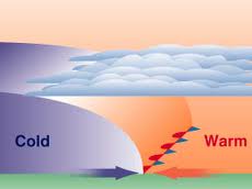
Cold Front - A cold front occurs when a mass of cold air pushes in on a mass of warm air. The cold air forces the warm air to rise rapidly. This creates heavy rain as the air is forced up at a great rate. A cold front is shown on a weather map as blue triangles on a line.
Stationary Front - Stationary fronts occur when a cold front collides head on with a warm front. The warm air is forced over the cold air but becasue the warm air mass is so large it holds the cold front from moving forward. This front creates heavey rain over a certain area for a long period of time. It is shown on a weather map as a cold front over top of a warm front.
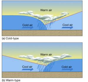
Occluded Front - Occluded fronts occur when cold air catches up with cool air or vise versa. This causes the warm air between the fronts to rise rapidly creating rain. This front is shown on a weather map as a half circles and triangles facing the same way.
Physical changes to the land
Vegetation Removal
Cliffs collapse
Change of river mouth
Swollen Rivers
Riverbank erosion
|
Landslides
Topsoil removal
Deposition of silt
Deposition of debris
|
Cultural effects of flooding
Possible economic Threats
- Commercial Property
- Farm crops and livestock
- Transport Facilities
- Tourist attractions
- Recreation Facilities
Possible economic opportunities
—- land
—- tourism
- —infrastructure
—- employment
Possible social threats
—- personal property
—- injury and death
- —trauma and disruption
—- public health
—- buildings and building services
—- electricity
—- water
- —waste
—- transportation
—- communications
Possible social opportunities
- —Families
—- Community
—- Aid Agencies
How people increase and decrease the effects of flooding
Increasing the effects
•Increased run off and erosion resulting from land management decisions
•Poor emergency preparedness
•A lack of flood insurance
•Poor emergency preparedness
•A lack of flood insurance
Decreasing the effects
PROTECTION
•Reduce runoff and erosion in the catchment
•Build flood protection works – stop banks. Flood dams, channel straightening
•Improve drainage systems
•Flood forecasting
•Emergency preparedness
REGULATION
•Controls on the removal of vegetation and the use of water
•Limit new buildings on flood plains
•Building codes related to drainage
•Zone flood prone areas for parks and golf courses
RELOCATION
•Relocation of roads, amenities, buildings.
•Evacuation
COMPENSATION
•Flood insurance
•Subsidies and public relief
Why has the threat of a flood increased?
•Catchment areas like roads, footpaths, parking areas and roofs don’t allow soakage and seepage.
•Debris blockages under bridges and culverts can restrict water flow
•Streams are often filled in, piped or diverted as cities grow. Smaller waterways cant handle the increased run off.
•Topsoil for new subdivisions can clog the waterways
•Efficient storm-water systems can overflow rivers by channeling too much water into them too quickly
•Land cleared of vegetation for new pastures or building cannot cope with increased run-off.
•Farmers and developers who drain swamps and wetlands increase the risk
•New buildings built too close to rivers
•Many people are not prepared for floods
Activity 1
The following activities are designed to make you think about flooding and the environment.
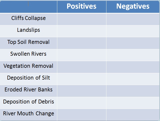
List all of the positives and negatives of flooding. These can be either cultural or physical.
Activity 2
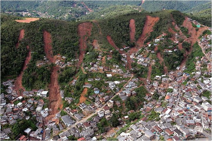
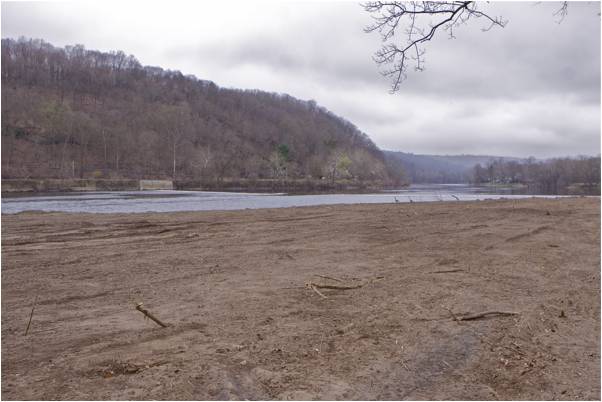
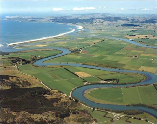
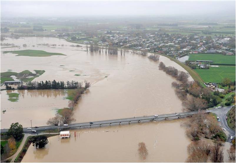
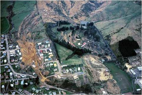
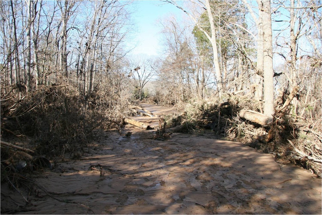
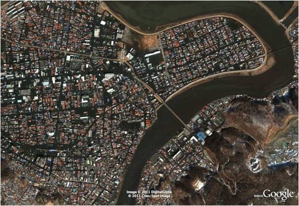
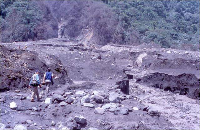
Looking at the following photos - What evidence is there that this areas has been in flood or experienced heavy rainfall?
- List the effects that the flooding in the pictures has had on the land
- List the effects that the flooding in the pictures has had on the land
|
|